
Main OBSERVING SITE
Driving Directions.
Jackson County Gravel Pit
Shale City Rd, Ashland, OR 97520

Merge onto OR-66 E/Green Springs Hwy 66
Turn left onto Dead Indian Memorial Rd 6.7 mi
Turn left onto Shale City Rd 0.2 mi
This is the gravel pit on the road for the trail head for Grizzly Peak. It is the First Left. Behind the locked gate.
North Medford High School Planetarium
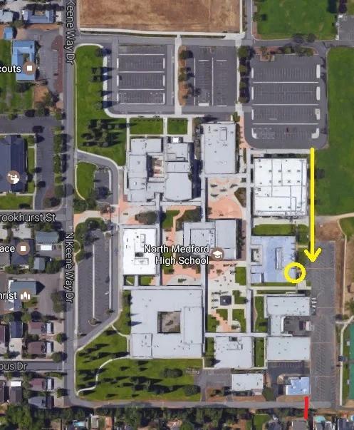
North Medford High School Planetarium
Meeting Site
Located at North Medford High School the Planetarium was constructed by Spitz Inc. in 1967 with a grant from the Federal Apollo Program. Please note there is a locked Gate (marked in RED) so use the access via the gym parking lot.
Other observing sites
Upper Observing Site
Just after mile 13 on Dead Indian Memorial Highway
Issues:
The Upper Observing site is unlocked but we have had some issues with broken glass, litter, and shells. It is slightly darker then the main site, but at the cost of 6 more miles and 2000 ft elevation.
Driving Directions:
The Upper Observing Site is at the rock quarry on Upper Shale City Road, off Dead Indian Memorial Rd east of Ashland. It is a windy road and takes about 20-30 minutes to get to the site from Ashland.
Directions from Interstate 5:
Take Ashland Exit 14
From the overpass, proceed East (away from town) on Ashland St. (Hwy. 66)
Proceed on Highway 66 for 1/2 mile to the Ashland Municipal Airport
Turn Left on Dead Indian Memorial Road
Follow Dead Indian Road up to mile marker #13
Turn left on (Upper) Shale City Road; the road is narrow, but paved
Follow Shale City Road for 1/2 mile
Look for a dirt driveway on the right -- this is the driveway onto the site
Follow the driveway

Getting onto Dead Indian Memorial Highway.
Turn off to the left just after mile mark 13.